Building on the past: Addressing geotechnical risks on mined land for tomorrow’s infrastructure

For developers eyeing reclaimed mines for new infrastructure, hidden subsurface conditions can make or break a project. By reconstructing a mine’s geotechnical story, targeted assessments identify settlement and subsidence risks before design begins. In this article, we share how these evaluations support smarter site selection, fewer surprises, and a more reliable path to project success.
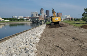
We’re starting to think about mined land differently. Once considered permanent wastelands, abandoned and reclaimed mines are being recast as viable sites for new infrastructure, including clean energy generation and storage facilities, processing plants, data centers, and transportation infrastructure such as roads, railways, and airports.
Once considered permanent wastelands, abandoned and reclaimed mines are being recast as viable sites for new infrastructure.
Repurposing mined lands can be attractive to developers and mine owners alike. These are large, contiguous tracts of cleared land with road access, water, and grid connection, all qualities that can save development costs and regulatory effort. Developers can be enticed by state and federal tax incentives to build renewable energy and other facilities on former mines. Mine owners can find new revenue streams by repurposing portions of their mines for on-site electrical generation.
The hidden challenge below ground
However, new development on reclaimed or abandoned mines can pose geotechnical challenges: hidden mine features, complex terrain, and, particularly, the risk of ground movement over time. In surface mines, mine spoils—non-ore-bearing waste rock left over from excavation—are often placed in the mined pit, where they may settle for many years, even decades. In underground mines, portions of the underground workings may collapse long after abandonment, potentially causing subsidence or localized sinkholes on the surface.
A structure built on shifting ground may experience differential settlement—when two or more parts of a structure settle at different rates—which can damage its foundation and threaten long-term stability. Assessing and mitigating the risk of differential settlement is possible; however, we must map, measure, and project it carefully.
Uncovering a mine’s geotechnical story
Perhaps surprisingly to some, much of the information we need can be gathered at a desktop level before setting foot on site.
Applying a powerful combination of geotechnical engineering, subsidence engineering, and underground mining expertise, along with advanced GIS and remote sensing capabilities, Barr helps mine owners and developers understand the risks from ground subsidence, differential settlement, and other mine features by reconstructing a mine’s complex subsurface history. By determining when and where spoils were placed, or underground workings were developed, we can identify hotspots for potential surface subsidence or differential settlement, estimate settlement rates, and project how long it will take for mined land to reach its final resting place. Equipped with this geotechnical knowledge, mine owners or developers planning an infrastructure project can avoid unstable areas and design lasting foundations.
Perhaps surprisingly to some, much of the information we need can be gathered at a desktop level before setting foot on site, and that’s where we begin.
“We have the expertise in geotechnical and mining fields necessary to analyze topographic data, mine maps, geologic maps, core data, historical aerial imagery, and regulatory records, then piece together a history and a map of what’s happened underground—even after mining has ended and a mine has been reclaimed or abandoned,” said Hayden Christensen, a geotechnical engineer at Barr. “We’re uncovering a mine’s geotechnical story.” Hayden frequently teams with Greg Hasenfus, senior mining engineer, who has over 40 years of experience in mine-related subsidence, to tackle mine subsidence and differential settlement challenges on mined lands.
Using the past to visualize future risk
A history and a map—a combination of time and space—is vital. Project owners need to know not only where the mine spoils are, their footprint, and their thickness, but also when and how they were placed. With this information, we can estimate the extent of settlement that has occurred and project how long it will continue. In surface mines, younger and thicker deposits of mine spoils will settle more than older and thinner ones. In underground mines, we focus on understanding past and present geologic and hydrologic conditions to estimate the future stability of abandoned mine workings.
With the necessary data in hand, Hayden and Greg partner with Barr’s GIS team to build a digital rendering of a mine’s present and projected future subsidence conditions. It resembles a topographic map that has been altered to reflect an up-to-date record of the mine’s workings—excavations, spoils, and other ground disturbances—highlighting areas of increased risk of ground subsidence. It’s a high-level view of future settlement potential that helps project owners evaluate project feasibility and siting.
There may be data limitations. Records may be scant for mines abandoned long ago, and available topographic data may lack sufficient detail to make a reliable assessment. In these cases, we can apply in-house drone-supported remote sensing technologies, such as LIDAR, or satellite-derived InSAR measurements. These tools allow us to detect and quantify ground movement over time. By comparing data across multiple time points, we can estimate settlement rates and identify high-risk zones with excellent detail.
Tailored solutions for every project
While there are plenty of good reasons to repurpose mined lands for infrastructure, it should be done with due consideration for ground subsidence and/or differential settlement.
Our assessments result in siting and/or design recommendations for addressing mine subsidence that are tailored to a specific proposed infrastructure project. On a proposed wind power project, for example, we consider a wind turbine foundation’s limited tolerance for differential settlement. For processing plants and other large facilities, finding a sufficient area with low differential settlement risk is critical. “As an integrated engineering firm, we have the engineering expertise to tailor our assessments for virtually any infrastructure project, from electrical substations to data centers,” said Greg. “The important takeaway is that we meet clients wherever they are in their planning journey, whether it’s a high-level feasibility study or a detailed, design-phase analysis.”
While there are plenty of good reasons to repurpose mined lands for infrastructure, it should be done with due consideration for ground subsidence and/or differential settlement. Commissioning these assessments as early as possible, and within the context of past mining operations and local geology, helps mine operators and developers achieve optimized, resilient, and cost-effective site selection, design, and construction. To learn more about how Barr can support your next project on mined land, contact us.
Joining us at MINEXCHANGE?
Come chat with Hayden, Greg, and other Barr engineers and environmental specialists about Barr’s services to the mining industry. Visit us at Booth #1302.
About the authors
Greg Hasenfus, senior mining engineer, has 40 years of mining engineering and renewable energy experience, helping clients with operational challenges, due diligence, and research and development. He is well-versed in underground mining ground control, mine subsidence, and all phases of geotechnical project work, including monitoring and instrumentation, laboratory analysis, field data collection and analysis, and problem solving.
Hayden Christensen, geotechnical engineer, is a professional engineer with over half a decade of geotechnical and mining engineering experience on projects involving mine subsidence, underground mining ground control, blasting, numerical analysis, and foundation design. He often serves as the project manager or technical contributor on subsidence engineering and underground mining-related projects.
Related project
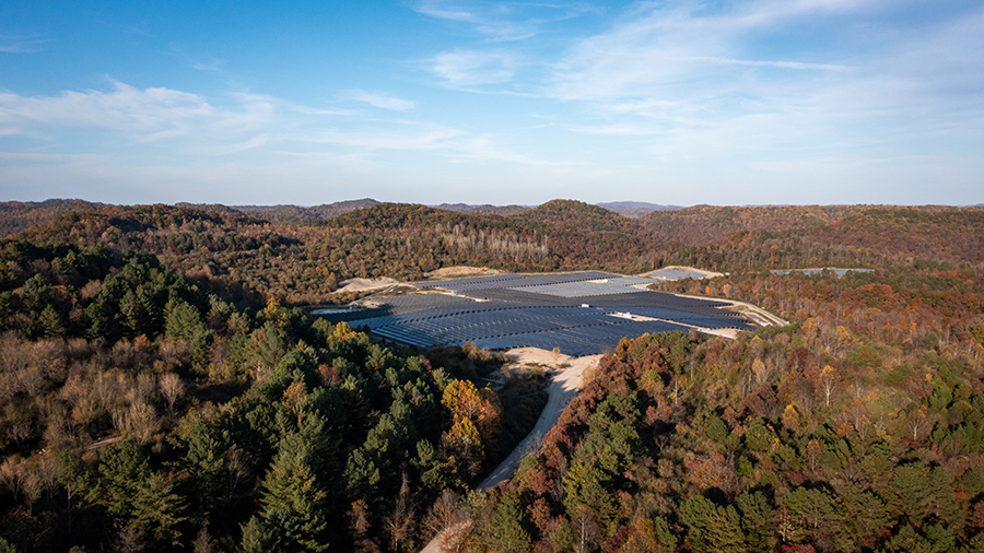
Solar on reclaimed coal mine, settlement and subsidence risk analysis
Barr partnered with a confidential power client to assess the feasibility of a 100 MW solar power project on a reclaimed mountaintop coal mining site in the Appalachian Mountains. Our mining and geotechnical engineers completed a desktop-based analysis of settlement risks, potential underground mine features, and differential movement using site-specific data, LiDAR, and InSAR. The team provided actionable recommendations for setbacks and design concepts, helping the client move forward confidently with detailed project planning. This work reflects Barr’s ability to turn complex site histories into opportunities for sustainable energy development.