A climate change vulnerability assessment (CCVA) serves as the first step in climate adaptation planning by identifying the greatest risks from climate change. When Hennepin County wanted to learn how the changing climate is affecting its people, water resources, infrastructure, natural systems, and the built environment, Barr was hired to develop a CCVA for the county, including Minneapolis and its densely populated suburbs.
Overlaying the data
Barr leveraged GIS open-source data to show how climate change is impacting Hennepin County. For example, we identified facilities, roads, and sidewalks vulnerable to extreme precipitation events using FEMA floodplain and localized flood risk data from the Metropolitan Council. We also identified where natural resources are at risk by employing Minnesota Department of Natural Resources’ Metro Conservation Corridors and the U.S. Geological Survey’s land cover data.
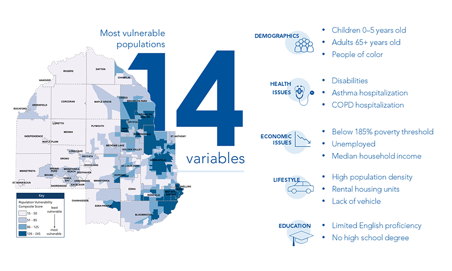
Identifying vulnerable populations
A primary aspect of the plan involved identifying population vulnerability in Hennepin County. Health, demographic, and economic data from the U.S. Census Bureau was used to reliably identify and map population vulnerabilities. Barr identified 14 vulnerability variables, ranging from median household income and population age to English-language proficiency and asthma hospitalization rates. We mapped variables at the census-tract level, classified them, and assigned a subsequent score, which was then added to create a composite population vulnerability map. Areas with the highest scores represented populations most vulnerable to climate change.
The CCVA equipped Hennepin County with the data to build a more climate-change-resilient future for its people, natural resources, and infrastructure. The CCVA served as a foundation and technical reference for the development of the Hennepin County Climate Action Plan, allowing county work groups to present data-based strategies, initiatives, and actions aimed at building resilience to the risks posed by climate change.